Teaching Thinking and ICT


ICT, Talk and Thinking

Visual and Creative Thinking

Thinking through the web


Thinking Skills, ICT and Geography
Unit 10 - A Village in India

Helen Burrell
High Spen Primary School, Gateshead


The challenge for this mixed year 3/4 class with a wide range of ability was to look at the similarities and differences between our own village and Chembakolli in India.


We began by looking at maps. The class were used to looking at maps of High Spen and the Year 4 pupils had studied the history of the village and changes in it over time. In order to get them to focus on the physical aspects of Chembakolli and its relative location within India we began by playing what the children have called 'the 5 second game'; a thinking skills strategy also know as 'Maps from Memory' where children collaborate to reconstruct a map by taking it in turns to see the complete map a few seconds at a time(for more information about this strategy see David Leat's Thinking Through Geography). In mixed ability groups they took it in turns to look at a completed map which was held by the teacher. They had just 5 seconds to study the map and then return to their group and fill in a blank copy. The important elements of this task are that the groups work out a strategy. At this stage they were beginning to talk about which parts of the map they need to focus on saying things like 'we've got the fields, you look at the rivers.' Exchanges like this show that they had begun to work together and had devised strategies for completing the task. This collaborative work is a favourite of the children and over the year they have become much better at focussing on different areas and planning what to look for. As all of the words were unfamiliar the spellings were imaginative! However the landscape and the main geographical features were shown more accurately.

Using this approach helps to develop co-operative and discursive skills but it also a very useful tool for making children look carefully at the features of a map. By working together children noticed features they may have otherwise missed and the opportunity for using geographical language then occured in the discussion afterwards. For example one group found all of the landscape features but another group focussed more on habitation. Collaborative group work like this is a feature of the approaches recommended by Alistair Smith. In 'Accelerated Learning in Practice' he talks about building a sense of success in the classroom by 'using co-operative learning techniques to build team skills'

Once they had a grasp of the location and the region we looked at the map of the village using the large screen. We pulled up a map of High Spen beside it and as a class began comparing the two. Different children came out and pointed to aspects such as churches and temples. The children were in their already established ICT pairs/threes in the ICT suite and as we discussed they began making notes on the similarities and differences we were finding.

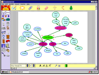
To prepare for the next session I took the notes that certain groups had made and put them into Kidspiration (Inspiration, Inc) with each idea in its own text box. As a class we looked at these on the large screen and a discussion arose as to how we could present the information. As the children had already worked with Kidspiration and were familiar with using concept maps in most subjects, they had some very good ideas as to how concept maps could help to sort the information. They were keen to show that there were many links between information and eager to explain how it could be presented.

Just by presenting information in text boxes as separate statements generated a high level of discussion. Children were able to point at boxes and explain why certain statements fitted together. An interactive whiteboard would have been a bonus here to allow children to join statements themselves either in colours or by manipulating the boxes. We used a large sheet of white paper pinned to the wall the computer was projecting on and coloured markers. Children were able to justify their choices with reasons such as:


" These are all buildings so we could group them and link them together, then these two are for leisure so they could link."

We decided that two concept maps needed to be created, one for each village, then we could compare and put explanations in the text part of the programme.


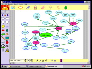
We had already established pairs who worked well together on the computers, usually a poorer reader with a better one. Using the frame on the screen as a guide they began creating their own concept maps. Starting with High Spen seemed logical, as they didn't have to refer to the map very often to check ideas. Discussion between Year3 and Year 4 pupils began on whether we should include things that used to be in the village. The Year 4 children had looked at the history of the village in depth and they knew there used to be a cinema and more shops. This led to a discussion on our knowledge of the history of Chembakolli. Could we justify taking our previous knowledge of High Spen into account? We decided that we could only use the knowledge we had gained from looking at the maps we had in front of us. This level of discussion came from the links the children had been making and their ability, through other thinking skills strategies, to question and reason at quite a high level.

One of the benefits of working with concept maps is that they require children to make links between ideas and to find reasons and justifications for these links. When we first began using concept maps the children would join everything to the central idea and there would be no thought in their attempts to link ideas. This activity took place half way through the year and the maps show that children have begun to make links between ideas and concepts and discussion showed that they could justify and explain their links clearly. (If children are required to justify and explain their maps a 'pole bridging' improvement is made which means that the children are re-enforcing their own learning and building upon it.)

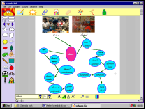
The children also used photographs to enhance their maps and spent a long time deciding which pictures were suitable for which aspect of the maps. Some even insisted on using the digital camera to take pictures of our school to use as a comparison. This pair decided just to compare school life and their maps were complex but informative.
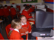
The concept maps that the children produced were informative and focused their thinking on the similarities and differences between the two villages. We use concept mapping like this at the beginning and end of most topics and the children are keen to see their own knowledge expand in a logical way. The benefits of concept mapping can be seen in most topic areas; children extend logical ideas and begin to think carefully about groupings and links. This activity in particular raised the skills and knowledge of the children in Geography. They were motivated to learn about life in Chembakolli from looking at the map and from seeing their own words on the large screen ready to be turned into a useful tool. (They are keen to see themselves and facilitators of their own learning and love the idea that what they produce will help not only themselves, but others, to learn.)

By adopting this thinking skills strategy the children not only became much more focused on the similarities and differences between themselves and children in Chembakolli but they were motivated to find out more. As a teacher I couldn't ask for more than for the children to be motivated, keen learners and the feedback from the children during our weekly 'what I have achieved' sessions proved that they too are proud and pleased with what they have learned and achieved.

Further information
Leat, D. (1998) Thinking Through Geography Cambridge: Chris Kington Publishing ISBN 1-899857-42-7.
Smith, A. (1998) Accelerated Learning in Practice Stafford: Network Educational Press (http://www.alite.co.uk/ )
Smith A., Call, C and Batton J. (1999) The ALPS approach: Accelerated Learning in Primary Schools (revised edition) Stafford: Network Educational Press Ltd ISBN: 1-855390-56-6.

The kidspiration sample files used in this activity are linked here;

Links for PC;HBChembokolli
Links for Mac;HBChembokolli

Return to paragraph 5

Note that you may need to install the demo version of Kidspiration before these links will work...

  Demo version of Kidspiration for PC - and for Mac

Demo version of Inspiration for PC - and for Mac

Kidspiration (Inspiration Software, Inc. www.inspiration.com )

Return to Top